Research Achievements and Directions
RESEARCH INTERESTS
- Mesoscale Dynamics
- Severe Weather
- Low Level Jet, Gravity Waves and Cold Pool
- Diurnal Cycle of Rainfall
- Sea Breeze
- Mesoscale Numerical Modeling and Forecasting
Double Low-level Jets, Diurnal Offshore Propagation of Rainfall, and Wave-Convection Coupled Bands.
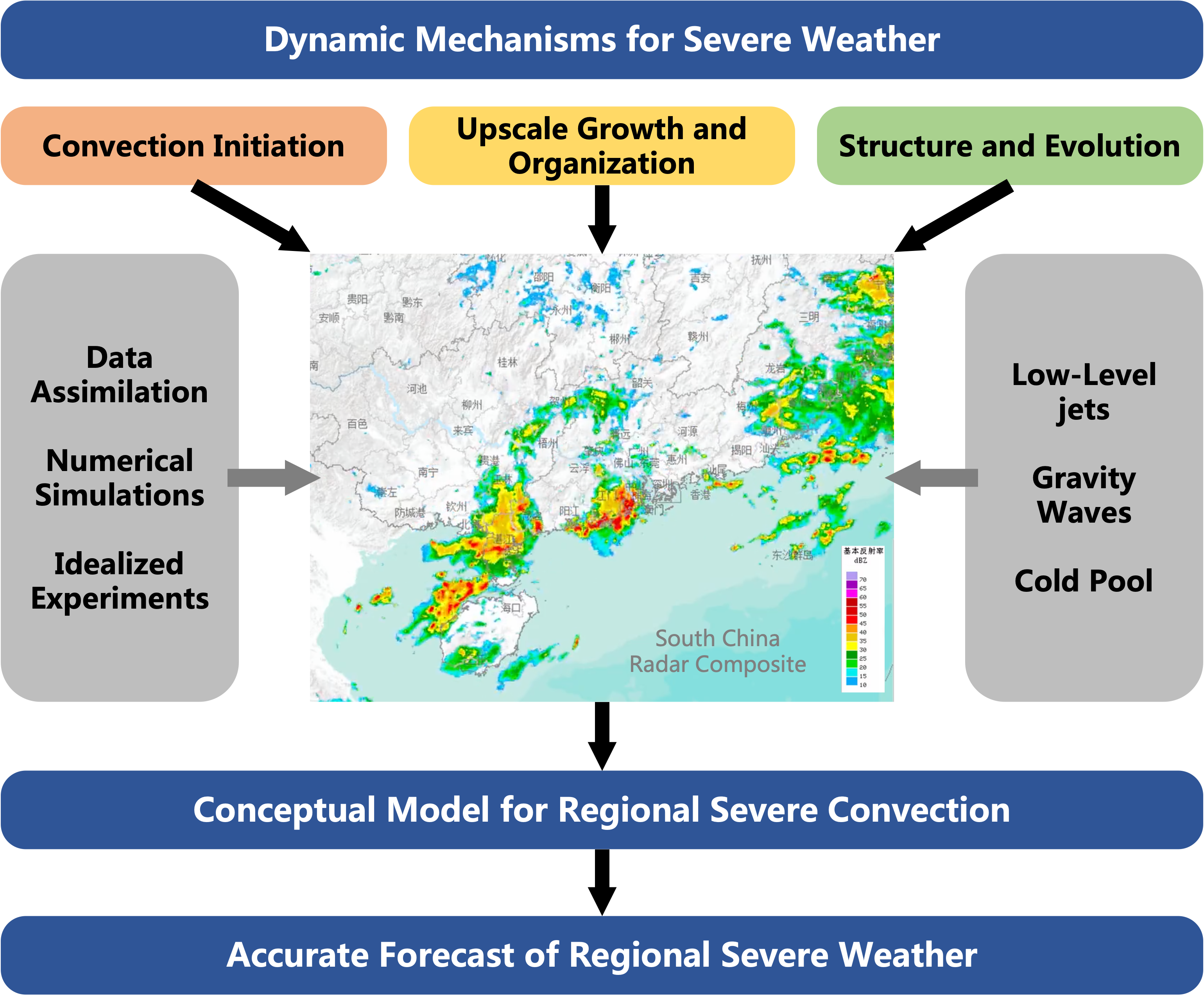
1. Characteristics and dynamic mechanisms of extreme weather events (strong convection and heavy rainfall)
Extreme weather events such as heavy rainfall and strong convection pose a severe threat to social economy and the safety of people’s lives and property. Due to the local, sudden, and complex multiscale interaction characteristics, it has always been a focal point in atmospheric science research and a challenging aspect in forecasting operations. The in-depth study of the occurrence and development mechanisms of extreme weather can effectively enhance the targeted improvement of related forecasting and warning capabilities. It holds significant importance for national and local disaster prevention and reduction and carries important scientific significance and social value.
The triggering and maintenance of heavy rain and severe convection are not only influenced by atmospheric circulation (such as the summer monsoon) and weather systems (such as cold fronts, quasi-stationary fronts, etc.) but are also related to mesoscale phenomena (such as low-level jets), boundary layer processes, topography, land-sea differences, gravity waves, and other forcings. Our research focuses on understanding the relative contributions and interactions of each factor, with particular attention to two important factors: low-level jets and gravity waves.
A. The characteristics, dynamic mechanisms, and theorical models of low-level jets
Low-level jets (LLJs), defined as the wind maximum in the lowest few kilometers of the atmosphere, occur globally as an important atmospheric phenomenon. Since LLJs are closely related to precipitation, wind energy, and pollution transportation, it has been a hot topic and forefront area of global atmospheric science research.
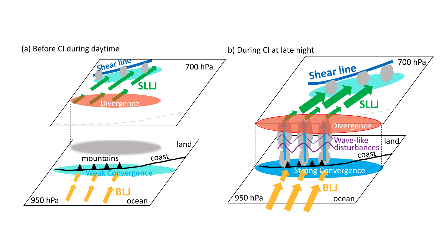
In recent years, comprehensive research on low-level jets has been conducted using observations, simulations, and theoretical models. The main research achievements are as follows: Based on high-resolution wind profile data, the observed LLJs can be classified into boundary-layer jets (BLJs) and synoptic-system-related LLJs (SLLJs), and the characteristics and formation mechanisms were revealed respectively (Du et al. 2012, JMSJ). Further utilization of long-term high-resolution mesoscale model datasets (Du Model Data) allowed for the first comprehensive summary of the objective classification, spatiotemporal distribution features, and formation mechanisms of low-level jets in China (Du et al. 2014, J. Climate; Du et al. 2015, MWR). A simple one-dimensional theoretical model was established in collaboration with Senior Researcher Rotunno (recipient of the Rossby Award), quantitatively revealing the formation mechanisms of low-level jets in the United States (Du and Rotunno 2014, JAS). This paper quickly garnered widespread attention and recognition in the field. Additionally, the Du-Rotunno Model was successfully applied to explain low-level jet activities in eastern China (Du et al. 2015, JAS). The theoretical model for low-level jets is groundbreaking, and its core results have been published in the top-tier atmospheric science journal, JAS.
Based on a typical case of early-summer rainy season over Southern China, ensemble forecast analysis revealed the association of the SLLJ with inland frontal rainfall, while the BLJ was closely related to coastal warm sector rainfall (Du and Chen 2018, MWR). Further from the high-resolution mesoscale models, the vertical configuration of double low-level jets was found to play crucial role in the convection initiation of the coastal warm sector heavy rainfall (Du and Chen 2019, MWR). Statistically, the quantitative relationships between the two types of low-level jets and frontal and warm sector rainfall in the South China were elucidated (Li and Du 2021, JC). The diurnal variation of the boundary layer jet was found to impact coastal convection through dynamic convergence and thermodynamic moistening processes, providing theoretical support for the prediction of coastal warm sector convection (Du et al. 2020a, MWR). Moreover, the interaction between low-level jets and coastal terrain facilitated convection initiation and development. Quantitative analyses revealed that the mesoscale convergence at the exit region of the boundary layer jet, coastal frictional convergence, and terrain-induced mechanical lifting exhibited nearly equally important dynamic lifting effects (Du et al. 2020b). The interaction between low-level jets and the cold pool was also identified as a key factor in sustaining coastal convection (Du et al. 2020b, MWR; Mai, Du et al. 2023, MWR). The nonlinear quantitative relationship between the intensity of the boundary layer jet in the South China Sea and precipitation in South China was evaluated (Du et al. 2021, AAS).
We will extensively use various observations (such as doppler radars, wind profiler radars, satellites and so on.) along with high-res mesoscale numerical simulations as well as idealized models to deeply investigate the 3D thermal and dynamical structure of low-level jets and its role in the initiation, evolution and organization of strong convection, trying to solve the chicken-and-egg problem of low-level jets and strong convection (or, heavy rainfall events). We try to build international high-level physical models with local characteristics to explain the dynamic mechanisms of the initiation and evolution of strong convection and provide theoretical basis for severe weather forecasts.
B. Gravity Waves and Convection
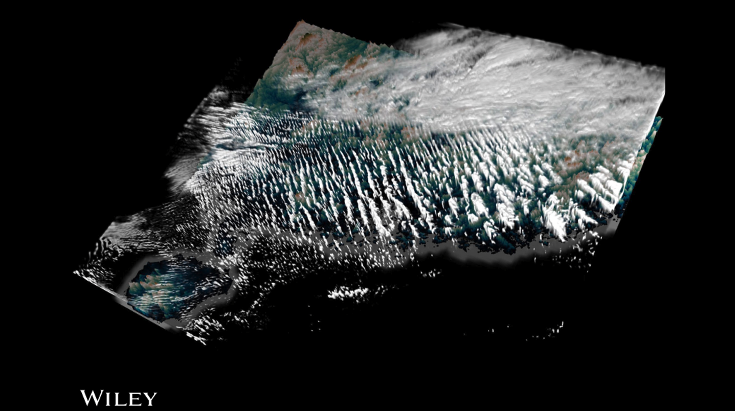
Gravity waves are ubiquitous phenomenon observed in the atmosphere which can be generated by mountains, front/jets, convection and so on. There exists an interaction of gravity waves and convection, that is, gravity waves may impact the formation and development of convection while convection is also an important source of gravity waves. We used both observational data and convective-permitting mesoscale simulations to investigate the main features and dynamics of a banded convective activity over Southern China (Du and Zhang 2019, JGR), and found that wave ducting played an important role in maintaining the banded convective activity by keeping the energy in the duct at low levels. In addition, we also found that it was of great significance for wave-CISK hypothesis to maintain the banded convective activity through a positive feedback process with latent heating. We further examined the predictability of these wave-convection coupled bands and found that the practical predictability depended more on the correct initial state in terms of thermodynamics rather than physical parameterizations, and the phase of waves was unpredictable intrinsically (Du et al. 2021, JGR). Waves generate from the balances among latent heating, nonlinear advection, and adiabatic heating/cooling. The imbalances among the three factors above, timing of wave generation and the amplitudes of wave couplets can be described by the local heating rate (Yang, Du et al. JAS).
We will use numerical models and idealized simulations deeply discuss the wave-convection interaction and the role of moist processes in generating and propagating gravity waves.
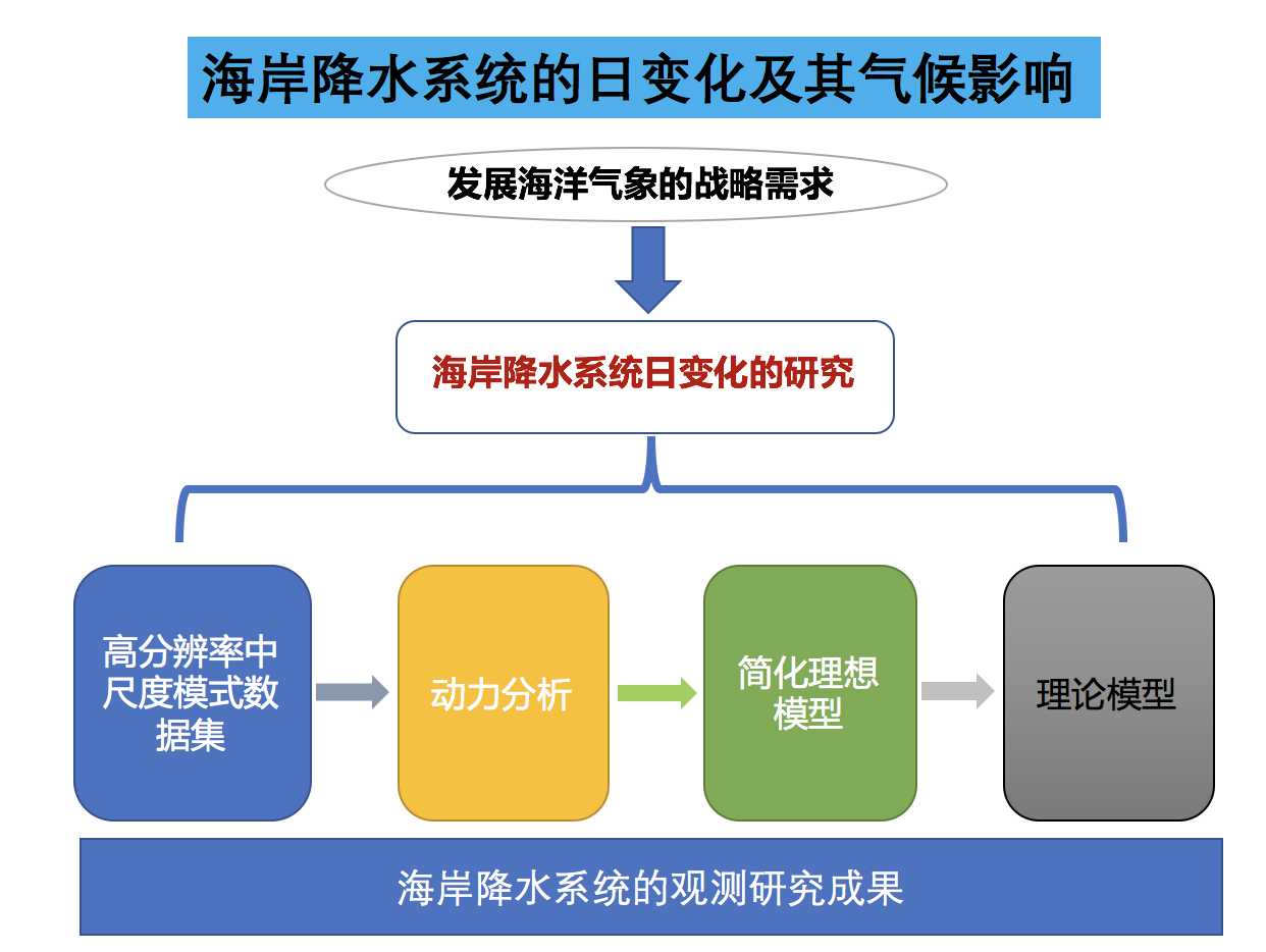
2. Diurnal Cycle of Rainfall and Winds
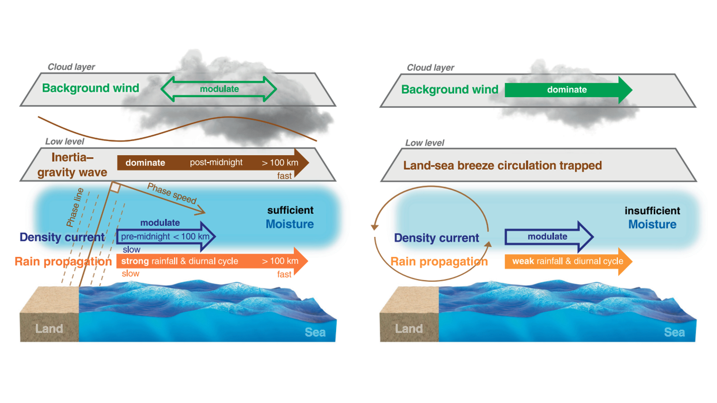
Diurnal cycle is an important aspect of weather and climate. Understanding the characteristics and mechanisms of diurnal variations helps improving the capability of weather and climate forecasts. In recent years, we extensively examined the diurnal variations of precipitation and winds, gave the theoretical explanation through modeling, and enhanced the understanding and forecasting capability of the diurnal cycle of rainfall and winds. Using long-term hourly high-resolution WRF Model data (Du model data), We revealed the link between diurnal propagation signals of winds and precipitation east of the Tibetan Plateau for the first time and found that the propagation speeds changed over seasons. We employed a high-resolution mesoscale model as a diagnostic tool and suggested that the phenomena were conducted by the interaction of large-scale mountain-plain thermal circulation and mid-level background steering flow (Du et al., 2014, J.Climate). We build a simple 2D linear land-sea breeze model to investigate the characteristics of diurnally periodic wind signals off the east coast of China. This was the first study to reveal that the low-level diurnally periodic wind signals propagated eastward off the southeast coast while diurnal wind variations off the northeast coast were nearly in phase, which was primarily caused by gravity waves, innovatively giving a reasonable explanation through theoretical modeling (Du and Rotunno 2015, JAS). We further added a background wind into the 2D linear model and found that the background wind was a key factor for the offshore and onshore propagation of the diurnal cycle of rainfall and winds near the south coast of China (Du and Rotunno 2018, JAS). In addition, we also found that vertical wind shear influenced the gravity wave propagation in the land-sea-breeze circulation. There was a critical level where gravity wave propagation was largely attenuated. As vertical wind shear increased, the attenuation level decreased correspondingly (Du et al. 2019, JAS). Through a global survey of diurnal offshore propagation of rainfall, we found that latitude, moisture and background winds are three key factors for whether precipitation signals propagated or not, the propagation distance and speed features (Fang and Du 2022, Nature Comm.). Studies above build a good foundation for future research on diurnal cycle of coastal rainfall at different latitudes and under different background winds.
There are still several important problems to be solved:
- What are the dominant propagation mechanisms of the diurnal cycle of rainfall in different regions, especially coasts near the South China Sea?
- What are the similarities and differences between the diurnal cycle of rainfall at the coast and downstream of the mountains?
- What is the relationship between the diurnal cycle of rainfall and winds?
- What is the role of the diurnal cycle of rainfall in weather and climate change?
Based on our finished research, we will try to answer these questions extensively using observations, numerical simulations, theoretical studies and any other possible methods.
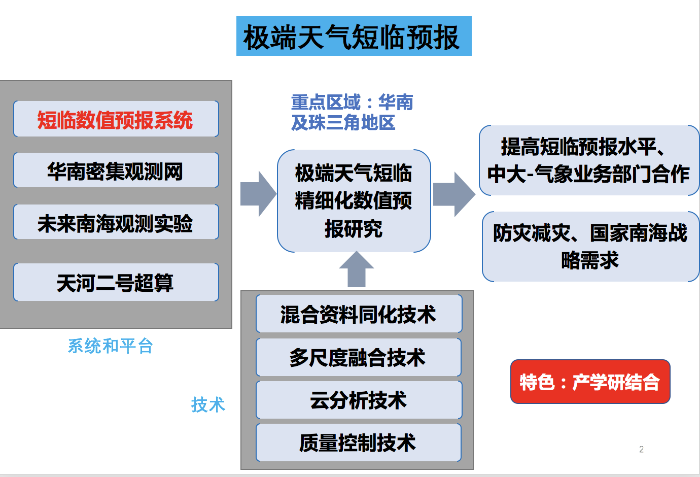
3. Short-term Numerical Severe Weather Forecasting
Severe weathers, such as heavy rainfall, intense convection and strong wind, are characterized by suddenness and complexity, which means it is challenging to forecast them. However, our capability of short-term weather forecasting is still limited, thus it is of great significance to improve the national and local technology of mesoscale short-term weather forecasting and data assimilation. To rapidly and effectively establish a series of sophisticated short-term forecasting systems with local characteristics has become a core task for national, provincial and local governments in order to improve the system for natural disaster prevention and mitigation. Main tasks include: the design and optimization of short-term numerical forecasting models, quality control of meteorological observational data, cloud analytics, hybrid data assimilation (3DVAR-EnKF Hybrid), multiscale fusion via incremental filtering (Patent US10330665B2), and so on.
We intend to conduct researches on short-term sophisticated numerical severe weather forecasting in coastal areas near the South China Sea, especially the Pearl River Delta in Southern China based on available short-term numerical forecasting systems, using local dense observational network, future observational tests on the South China Sea and Tianhe-2 supercomputer, combining various internationally advanced numerical forecasting technologies. Works above aim at improving short-term weather forecasting capability, applying latest research results into meteorological operations, promoting the cooperation between Sun Yat-sen University and meteorological departments and meeting the needs for disaster prevention and mitigation as well as the National South China Sea Strategy.